Road trip Upper Franconia: Cycling route Coburg – Bamberg
Road trip through Upper Franconia: From Coburg to Bamberg with event stops (planning for upcoming dates)
A relaxed cycling route along the Itz and Main rivers – combined with consciously planned, future cultural and event stops. With time logic, safety check, and ideas for a day or weekend format.
The cycling route Coburg–Bamberg: Overview & character
If you are looking for a route for a future excursion day that can be easily combined with event times, you are well served between Coburg and Bamberg: Many common route variants follow the Itzgrund up to the connection towards the Main and then lead into the Bamberg region and the old town. The big advantage for planning: Along river courses, the profile is usually rather moderate – ideal if a tour, concert, or event is scheduled to start in the evening.
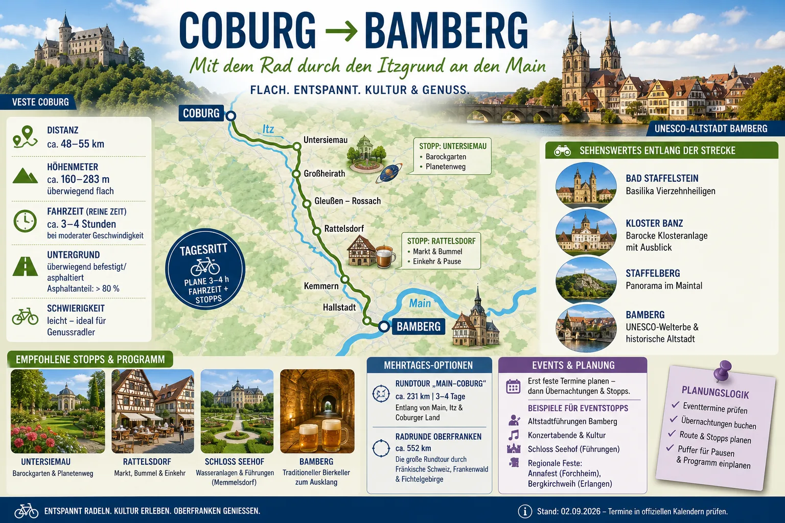
Depending on the chosen route (e.g., along signposted cycle paths, with or without small detours), many route planners typically estimate around 50–55 km. For realistic day planning, this rule of thumb has proven itself:
- Pure riding time: often about 3–4 hours (depending on speed, wind, breaks, and bike type).
- Total duration as an event day: better to calculate with 7–10 hours if learning/culture stops and a longer break are included.
- Surface & infrastructure: easily rideable in many sections; details (surface, closures, detours) should be checked on current maps/portals before departure.
In terms of content, a change of perspective is worthwhile: This tour is not just "from A to B," but a sequence of small, well-portioned stages – perfect for setting future event dates as a fixed framework and building the route around them in a relaxed way.
Start in Coburg: Day logic for future event days
The day ideally begins in Coburg with a clear target image: When should the evening program start – and how much "leeway" do you want to have on the way there? For upcoming event days (e.g., in the season 2026/2027 or later), this simple starting logic works reliably:
- Fix the event first: start time, location, admission/check-in, possibly ticket conditions.
- Then plan the arrival in Bamberg: with a buffer for city traffic, parking the bike, changing clothes, eating.
- Only then set the stops in between: learning/nature stop, longer break, photo stops.
Those who start early in the morning not only gain time but also flexibility: If a beautiful section along the way invites you to linger, the day remains stable – because the event serves as the "fixed star" of the planning.
Stops along the way: Itzgrund, Bamberg region & breaks
Along the way, there are places suitable as structured breaks – that is, stops that are more than just "a quick drink," but do not blow up the schedule. Good stops have three characteristics: easily accessible, easy to time, and easy to leave without stress.
1) Untersiemau: short learning and wonder stop
For many future tours, a first stop in the Untersiemau area is practical: A park/garden setting and a didactic element (e.g., a planetary trail, depending on the exact local setup) make it a break that also works with mixed groups. Tip for planning: 20–40 minutes is often enough to "let the stop take effect" without endangering the day's structure.
2) Itzgrund sections: consciously take it easy
Sections in the Itzgrund are excellent for slowing down: steady riding, short distances between towns, little decision pressure. Especially if there is still a program point in the evening, this quiet middle part of the tour is an advantage – it saves energy.
3) Rattelsdorf (or comparable stage town): break as a stable fixed point
For a future event day, it is worth scheduling a concrete break (instead of "we'll see"). A place like Rattelsdorf is conveniently located for many routes to take a longer break before continuing towards Bamberg. The name of the place is less important than the principle: a reliable meal break reduces stress, prevents hasty snacking, and stabilizes the rest of the day.
Optional: detours only at multi-day pace
Highlights in the Main valley (e.g., well-known viewpoints or monastery/pilgrimage destinations) are appealing as an idea, but can quickly become too much on an event day. If you consistently optimize the road trip for "bike + evening program," less is often more: better to skip a detour and arrive in Bamberg on time and relaxed.
Event stops & time planning: How culture fits into the tour
The crucial difference between a nice round trip and a real road trip with event character is the temporal dramaturgy. For upcoming events in and around Bamberg (e.g., tours, concert/theater evenings, exhibitions, seasonal formats), this planning logic has proven itself:
- Fixed program points become anchors: Event start and location determine the day's framework. Everything before that (stops, photos, "just quickly pop in here") is secondary.
- Buffer is mandatory: Consciously plan time for unplanned delays (weather changes, detours, longer breaks, traffic near the city).
- City entry as its own block: The last kilometers towards Bamberg often require more attention (turning, bike traffic, parking options). If you plan a block for this, you will arrive more relaxed.
- Define plan B before departure: If a stop is canceled, what alternative is "okay" (e.g., shorter break, later coffee, direct ride-through)?
Formats that are particularly easy to combine are those where you are not immediately "scheduled to the minute" in Bamberg, but still have leeway after arrival: e.g., a tour of the old town, an early dinner, and then an event. For the old town, it is also advisable to find out in advance about suitable bicycle parking options and any rules (e.g., in traffic-calmed areas).
Options for multi-day tours in Upper Franconia
If the first event road trip is to become a recurring format, it is worth taking a look at larger cycling networks and circular tour ideas in the region. The advantage: You can set future dates in Coburg, the Bamberg region, or Bamberg as "stage highlights" and expand the tours around them modularly.
- Multi-day loops along the Main and tributaries: Well suited if you want to reduce daily kilometers and instead include more culture and nature time.
- Regional themed routes: Depending on signage and provider, you can set culinary, river, or cultural focuses without having to plan each day from scratch.
For multi-day tours, it is advisable to coordinate accommodation and event visits early (especially on weekends or during holiday periods) so that the tour character remains relaxed.
Practical tips: relaxed, safe, plannable
- Check current route information: Check map/portal before departure (closures, construction sites, detours, ferries/bridges, if relevant).
- Pay attention to weather & daylight: For future event evenings, possibly plan return/late ride; lighting and reflective elements are basic equipment.
- Energy management: A real break or a clear meal stop prevents "running empty" shortly before the city.
- Take ticket and admission times seriously: For events, better to arrive too early than too late.
- Consideration in town passages: Especially in areas with mixed traffic, ride consciously defensively.
- E-bike & battery: If you ride electrically, calculate conservatively (wind, weight, support level) and plan a charging option if necessary.
Note: This article is for travel and route planning. It does not replace individual safety advice or up-to-date information from municipalities, organizers, or traffic authorities.
Sources & notes
For the specific route, surfaces, closures, and daily changes, please use current maps/cycling portals and local information. Background and orientation sources:
- UNESCO World Heritage Centre — Background on the classification of World Heritage Sites (accessed 2026-09-16)
- ADFC (Allgemeiner Deutscher Fahrrad-Club) — Safety, equipment, and tour information for cyclists (accessed 2026-09-16)
- Deutscher Wetterdienst (DWD) — Weather information for tour planning and safety (accessed 2026-09-16)
- OpenStreetMap — Map base for individual route checking (accessed 2026-09-16)